Directions By Car
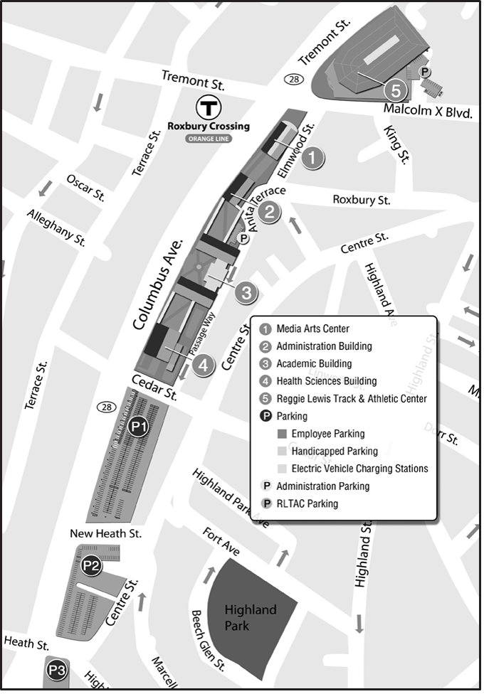
From Southeast Expressway - Southeast Expressway to Mass. Ave./Roxbury Exit-straight off ramp-through lights (Mass. Ave.) onto Melnea Cass Boulevard. Follow to the end and go left onto Tremont Street which becomes Columbus Avenue. Follow Columbus Avenue for approximately 1/2 mile. Look for the College on your left. Parking is available at the Cedar Street lot (corner of Cedar Street and Columbus Avenue).
From the Boston Logan Airport - 25 Logan Airport, East Boston, MA 02128. When leaving the airport, follow signs to Boston and go through the toll booth. The toll fee is $3.00. After the toll booth, enter the tunnel and follow the directions toward 93 South/Southeast Expressway. Follow the directions above.
South of Boston - Route 93 North to Southeast Express- way. Follow the directions above.
North of Boston - Route 93 South/Route 1 to Southeast Expressway. Follow the directions above.
West of Boston - Mass. Pike East to the last exit (Southeast Expressway). Follow the directions above.
Public Transportation
Trains - From Downtown Boston take the Orange Line toward Forest Hills. Get off at the Roxbury Crossing station. The College is located across the street on Colum- bus Avenue.
Buses - Columbus Avenue
22 - Ashmont Station - Ruggles Station via Jackson Square
29 - Mattapan Station - Ruggles Station via Jackson Square
66 - Harvard Station - Nubian Station via Allston & Brookline Village
Buses - Malcom X. Boulevard (Reggie Lewis Center stop - the College is located across the street on Columbus Avenue)
23 – Ashmont Station - Ruggles Station via Nubian Station
28 – Mattapan Station - Ruggles Station via Nubian Station